





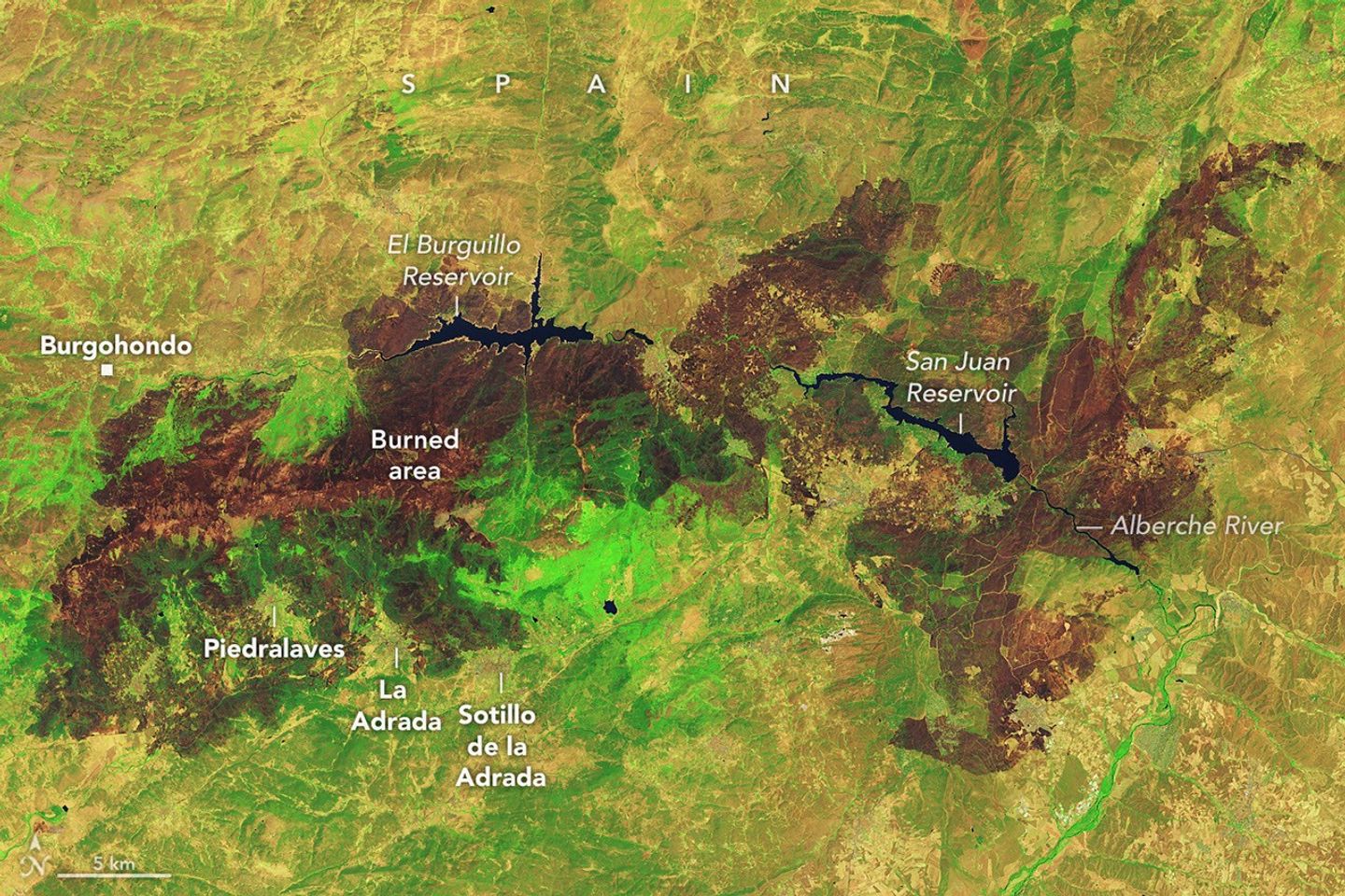
Wildland fires occur across Europe every summer, but those that erupted in Spain and France in July 2026 were among the largest and most disruptive the two countries have faced in decades. Some of the most consequential fires emerged in southwestern France’s Gironde Department and Spain’s Ávila and Madrid provinces in mid-July, where blazes forced hundreds of thousands of people to evacuate and destroyed hundreds of homes.Government officials in Spain say that a fire in Ávila, after charring around 50,000 hectares (124,000 acres), is the largest on record, surpassing a blaze that burned in Larouco, Quiroga, and Oencia in 2025. NASA satellites first observed signs of the Ávila fire burning near Burgohondo on July 22 and July 23. By July 24, it had merged with fires in neighboring provinces, pushing the total area burned to 77,000 hectares, an area about the size of New York City.The image above, captured by Landsat 9, shows charred landscapes around Burgohondo on July 29, 2026. In the false-color image, unburned vegetation appears light green, and burned areas appear brown. The two reservoirs in the center of the image were heavily affected. Flames tore through homes, restaurants, campgrounds, marinas, and other infrastructure surrounding the reservoirs, according to news reports.A similar crisis unfolded in southwestern France, west of Bordeaux. One of the largest fires to burn in France this decade charred more than 42,000 hectares, prompting large-scale evacuations and devastating the village of Le Porge. As of late July, fires had burned more than 90,000 hectares across France, more than any other season in decades, according to data from the European Forest Fire Information System.Environmental conditions months before the fires ignited made the landscape in both Spain and France particularly susceptible to burning, according to an analysis conducted by researchers with The State of Wildfires Project. Unusually wet winter weather enhanced vegetation growth in grasslands, shrublands, and forest understories, and then a series of sweltering heat waves and a period of drought parched the vegetation and primed it to burn. Several days of strong winds reaching 65 kilometers (40 miles) per hour at times served as the final trigger, the researchers found, fanning flames and encouraging rapid spread.On July 25, conditions at fires in southwestern France grew so intense that French firefighters reported the formation of a pyrocumulonimbus—a towering type of “fire cloud” that draws convective energy from the heat of the fires. An international group…
Lire l'article complet ici : NASA News: Destructive Fires Char Western Europe