












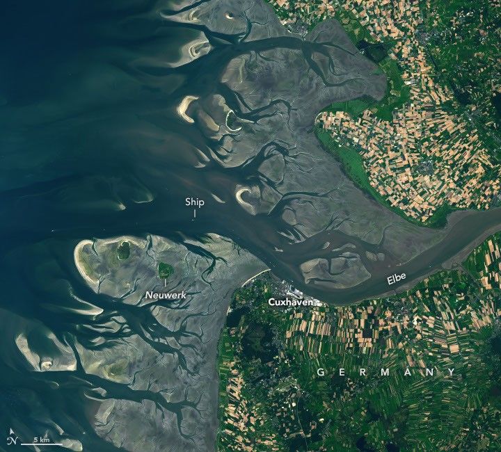
One of the major rivers of Europe, the Elbe flows more than 1,000 kilometers (600 miles) across the continent before reaching the North Sea. At its mouth, the low-lying landscape is continually reshaped by the rise and fall of the tides. These dynamic tidal flats are a boon to biodiversity while sometimes posing challenges for those navigating its waters and for communities living along its shores.The images above illustrate how the area changes with the tides. They were acquired on August 15, 2025, at low tide (left) and on May 11, 2025, at high tide (right) with the OLI (Operational Land Imager) on Landsat 9. The mean tidal range at Cuxhaven is 2.9 meters (9.5 feet), which is considered intermediate, or mesotidal. The tides are also asymmetrical, meaning the flood period is shorter than the ebb. This causes the incoming current to run faster and typically carry more sediment up the 140-kilometer-long (87-mile-long) estuary than it does out.The low tide exposes complex channels, sandbars, and mudflats around the river mouth. This wide zone of coastal wetlands is part of the Wadden Sea, which stretches from the Netherlands to southern Denmark and represents the largest continuous system of intertidal sand and mud flats in the world. Its habitats serve as important staging, molting, and wintering grounds for migratory birds, with more than 10 million passing through every year.A channel cuts through these natural features near the river’s mouth, allowing ships to reach Cuxhaven and Hamburg—the third-largest container port in the European Union—farther upriver. Dredging is required to remove accumulated sediment in the channel, and some ships can only pass through when the tide is high enough. The Elbe’s mouth also provides access to the Kiel Canal, which connects the North Sea and Baltic Sea and is the world’s busiest human-made waterway navigable by seagoing ships. At high tide (right), only a handful of small islands and sandbars remain above the waves. One of these islands, Neuwerk, is a tranquil tourist destination that is home to a few dozen inhabitants and the oldest building on the German coast. A brick tower, completed in 1310 and later converted to a lighthouse, was built to protect shipping on the Elbe from pirates and wreckers.These images show normal tidal variation in the area, but storms can push water levels much higher than a typical high tide. The highest water level measured at Cuxhaven—5.1 meters (16.7 feet) above Europe’s…
Lire l'article complet ici : NASA News: How the Tide Turns at the Mouth of the Elbe