






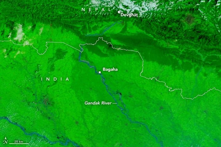
Storms drenched Nepal’s mountainous Lumbini and Gandaki provinces with waves of torrential rain between September 24 and 27. The deluge, arriving late in the monsoon season, triggered landslides and pushed the Gandak River, also called the Narayani, to record levels in both Nepal and India.With runoff streaming into the braided river system, water overtopped and breached embankments in several areas, inundating farmland and settlements along the river for hundreds of kilometers. As authorities assessed the full extent of the damage, news reports indicated that flooding and landslides had affected hundreds of villages and displaced thousands of people.Images captured by MODIS (Moderate Resolution Imaging Spectroradiometer) on NASA’s Terra and Aqua satellites on September 20, 2026 (left), and September 29, 2026 (right), show the extent of the flooding. The false-color images combine observations of infrared and visible light (MODIS bands 7-2-1) to make it easier to distinguish the water. Floodwater appears blue; vegetation is bright green; clouds are light blue.In many areas, water inundated seasonal fields on low-lying deposits of sand and silt within the river’s channel, called diara, where flooding is expected. However, it also breached embankments and flooded several settled areas, including parts of Bagaha, Areraj, and Fulia Khand.Data from Nepal’s Department of Hydrology and Meteorology indicated that a gauge in Devghāṭ reached as high as 11.94 meters on September 27, the highest since measurements began there in the 1960s. According to news reports, gauges in India along the Gandak that set new high-water marks included Bagaha, Dumariaghat, Rewaghat, and Lalganj.NASA has several tools and datasets available for tracking rainfall and flooding. Among them are Worldview, FLOOD Viewer, and the GPM IMERG Global Viewer. NASA Earth Observatory images by Lauren Dauphin, using MODIS data from NASA EOSDIS LANCE and GIBS/Worldview. Story by Adam Voiland. DD India (2026, September 29) Gandak River reaches record 91.25 metres at Bagaha gauge in Bihar. Accessed October 1, 2026. Dialogue Earth (2018, October 1) The silt farmers of the Gandak river. Accessed October 1, 2026. The Hindu (2026, September 30) Distress and panic in Bihar’s West Champaran district as Gandak river floods. Accessed October 1, 2026. The Kathmandu Post (2026, September 27) Relentless rain triggers floods, landslides across Nepal. Accessed October 1, 2026. The Kathmandu Post (2026, September 26) Incessant rains trigger widespread flooding in Tarai, disrupt key highway links across Nepal. Accessed October 1, 2026. National Herald (2026, September 27) Narayani river crosses danger level in Nepal, posing…
Lire l'article complet ici : NASA News: Rains Swamp the Gandak River